Wow, This sounds like a blast!
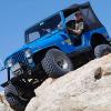
Taking Jeeps or UTVs?
I don't know if I can make it that week.
Hey, Wait a minute! I've been there!
I can give you some advice to plan this trip. These trails are easy to find. From Ouray go 3.5 miles south. Lower Engineer Pass trail starts here on the left. This trail is rough but not too hard.
I was there just 2 days ago. Check out this link for more info: http://www.jeep-cj.c...colorado-14887/
If you want to go on BlackBear Pass you still take highway 550 south of Ouray 13 miles. Here you will get to Red Mountain Pass. This is the 9th highest paved mountain pass in the US but you have only started your climb. At the pass there is a parking area on the right (when coming from Ouray) This is the begining of BlackBear Pass trail. If you take an UTV be warned, this trail becomes one way at the top. If you continue you have to go to Telluride. There you need a licensed highway vehicle to continue. The best way to come back it over Imogene Pass. To get to that trail you need to go through town. For more info on this route check out this link: http://www.jeep-cj.c...ne-passes-6540/
A note at camping I would not recommend staying at Ridgway State Park. I have never camped there and I don't think it's bad but it's half an hour to Ouray and a few more miles to the good trails. I would recommend staying at Eureka. This is an old mining site north of Silverton. It used to be a town but there aren't any buildings there anymore. The reason I recommend this place to camp it it's free and better yet its right in the middle of the mountains, with trails everywhere. You can drive a truck and big camper there by way of Silverton. Check out this link for more info:http://www.jeep-cj.c...-colorado-9630/
Some of the trails close to Eureka are Eureka Gulch, Minnie Gulch and Magie Gulch. Or if you head north you will get to Animas Forks Ghost town. There are lots of ghost towns in these mountains but this one is one of the coolest. You can also get back on the highway for a few miles to go to Blackbear Pass.
It is true that some of the better known trails such as Black Bear Pass and Imogene Pass are near Ouray but there are a lot more trails near Silverton and Eureka. That's where I prefer going.
Enjoy your trip!


")